Free satellite maps showing property lines
On this page
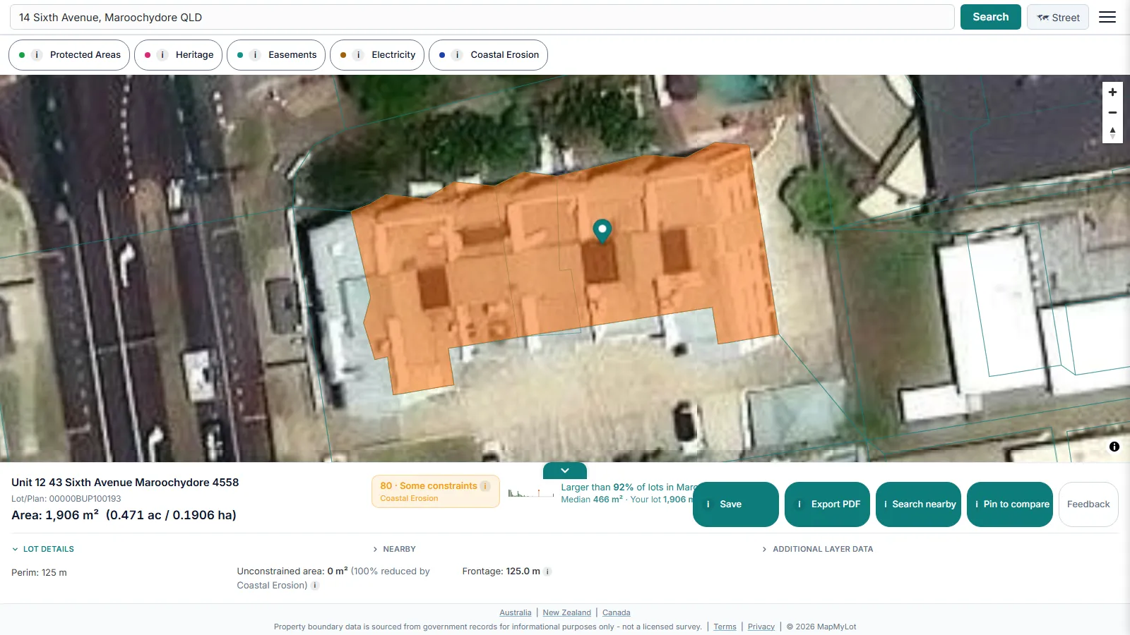
Everyone has zoomed into a satellite map trying to work out where their block actually ends - past the shed, before the neighbour's driveway, somewhere in that stretch of lawn nobody has ever measured. Search an address on MapMyLot and toggle the map to satellite view - the cadastral property boundary overlays directly on the aerial imagery, free, with no account required. It is the fastest way to see a legal boundary line against what is actually built on the ground: a house footprint, a driveway, a shed, a fence line, or the tree cover on a block.
View a property line on satellite imagery now - free
View property lines freeFive free address lookups a day, no account needed. Additional readouts depend on local data coverage.
Why satellite beats a plain boundary map

A street-map-only boundary view tells you where a line is drawn; satellite imagery tells you what that line means on the ground. Overlaying the two together - rather than switching between a government cadastral portal (in Australia, coordinated nationally by Digital Atlas of Australia) and a separate maps app - answers most practical questions in one view: whether a structure looks close to a boundary, how much of a block is cleared versus vegetated, or roughly how a fence lines up with the legal edge.
What else the readout shows
Beyond the visual overlay, the readout panel shows land area in square metres and hectares, perimeter in metres, and - where covered - straight-line distance to the nearest high-voltage power line, mapped flood zone, the coast, and the nearest park.
Note: cadastral boundary data is subject to positional variation by location and source dataset, and satellite imagery has its own alignment tolerance. For anything that depends on a precise legal boundary, engage a registered surveyor.
Free to check, Pro for unlimited
Five address lookups a day are free, with no account required, each including the full satellite/street map toggle. MapMyLot Pro, at A$19.99 a month, removes the daily limit and adds unlimited PDF boundary reports, useful if you are checking several properties in one session. A single PDF report is also available for A$4.99 without a subscription.
Satellite imagery and the cadastral boundary line update on separate schedules - the boundary reflects the government cadastral register for the property's jurisdiction, while the imagery underneath comes from the map provider and may be months or years old in a given area, particularly outside major urban centres.
Related checks
Check whether a fence sits on the boundary, see how big a block is with lot size in Australia, or if you are after a recent aerial view specifically, see the free alternatives to Nearmap.
Check an address in three steps
- Open the map, enter the street address and select the matching result.
- Confirm the highlighted parcel is the one you meant to check, then read its area and perimeter.
- Use satellite view for visual context and review the available readouts. If the parcel or figures do not match your documents, investigate the difference before relying on them.
What to do after your first check
Confirm you have the right parcel, then compare its mapped size and shape with the listing or your documents. If you need a copy for your own research, a one-off PDF property report costs A$4.99. For repeated checks, Pro costs A$19.99/month and includes unlimited lookups and PDF reports. Compare the options after checking the address. Reports are informational and do not replace a survey or title search.
View a property line on satellite imagery now - free
View property lines freeFive free address lookups a day, no account needed. Additional readouts depend on local data coverage.
Frequently asked questions
Is the satellite property line map really free?
How current is the satellite imagery?
Which countries have satellite property line coverage?
Is my area included?
MapMyLot currently covers:
- Australia: Queensland, New South Wales, Victoria, Tasmania, and the ACT
- Canada: British Columbia, Manitoba, New Brunswick, and Yukon
- New Zealand
- UK: England, Wales, and Scotland
Search your address directly to confirm. An address outside these areas will not return a boundary, and MapMyLot will say so rather than showing a guess.