Easements on my property: mapped and official checks
On this page
MapMyLot Pro can display mapped easements in Queensland, Victoria, New Zealand and a small central Canberra area. Search a covered address and open the Easements layer to compare the mapped easement with the parcel. Check the title and relevant plan or instrument to confirm the legal rights and restrictions, including where no easement appears on the map.
Check a property for registered easements
Check mapped easementsEasement overlays require Pro. Coverage: QLD, VIC, NZ and a small central ACT area. A title search is still needed for an authoritative check.
How to check for easements on a property
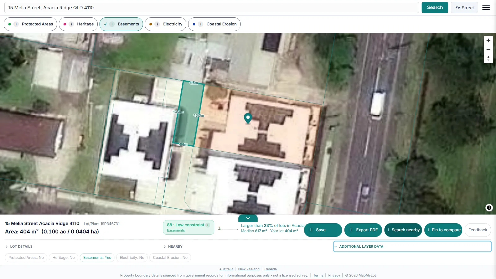
Search the address, then tap the Easements layer pill. Where a registered easement crosses the parcel, MapMyLot draws it clipped to the property boundary - so what you see is the easement crossing this specific lot, not a wider corridor across the whole neighbourhood.
What the readout shows

Tapping the Easements pill adds an easements indicator to the property readout, alongside the parcel's boundary, lot size, and proximity data from the same address search.
What a registered easement restricts
An easement is a registered legal right that lets a third party - most often a utility provider, a council, or a neighbouring property owner - use part of the parcel for a specific purpose, commonly drainage, sewer, electricity, or access. It restricts what can be built within the easement strip (structures generally can't sit over a drainage or sewer easement without special approval) and can meaningfully reduce the practically usable area of a block, even though the easement area still counts toward the property's total lot size. This is a parcel-crossing feature, not a zone the whole property sits inside - MapMyLot shows where the mapped easement runs across the specific lot.
Checking a New South Wales property
MapMyLot's easements layer does not yet cover New South Wales. For a NSW address, order an official title search through NSW Land Registry Services - registered easements appear on the title (folio) itself, which is the authoritative record in any jurisdiction, including the ones MapMyLot does cover. MapMyLot can still check a NSW property's mapped boundary and lot area, and a free proximity check against nearby parks, water, and powerlines.
Is my area covered?
MapMyLot's easements layer is currently live in:
- Queensland
- Victoria
- The ACT (a small central Canberra slice only - most of the territory is not yet covered)
- New Zealand
Not yet covered:
- New South Wales
- Tasmania
- Canada: British Columbia, Manitoba, New Brunswick, and Yukon
- The UK
If a property sits outside the covered list, or in the wider ACT beyond the small central slice loaded so far, MapMyLot has no easements reading for it - order an official title search through the relevant state, territory, or national land registry for an authoritative answer before a build or purchase decision. Addresses within cadastral coverage can still show their mapped boundary and lot area and a free proximity check.
Check a property for registered easements
Check mapped easementsEasement overlays require Pro. Coverage: QLD, VIC, NZ and a small central ACT area. A title search is still needed for an authoritative check.
Frequently asked questions
Is my area covered?
MapMyLot's easements layer is currently live in:
- Queensland
- Victoria
- The ACT (a small central Canberra slice only)
- New Zealand
Not yet covered:
- New South Wales
- Tasmania
- Canada: British Columbia, Manitoba, New Brunswick, and Yukon
- The UK